Quebec City Old Town Walking Tour: Upper to Lower Town Route
Quebec City’s Old Town asks a very practical question before it offers romance: how do we move through a city built on a roughly 60-meter rise between river trade and administrative power? That height is not decorative.
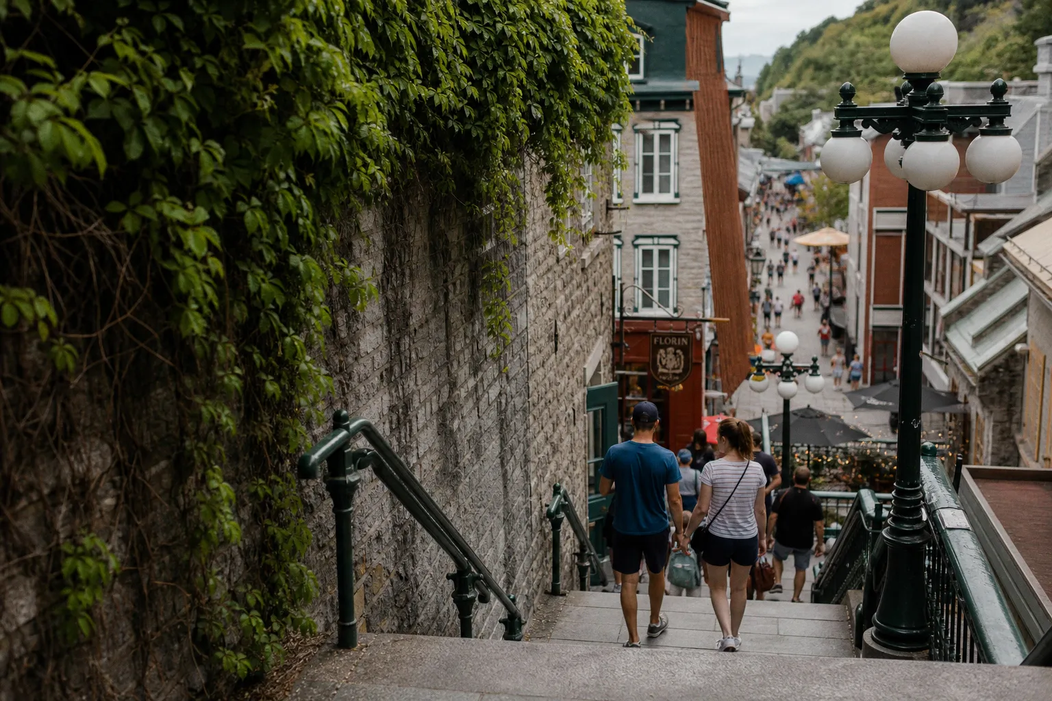
A good Quebec City Old Town walking tour should not treat that climb as a pretty inconvenience. The route from the fortifications and Dufferin Terrace down to Place Royale and Petit-Champlain is the city’s old supply chain made walkable: walls, stairs, funicular, market streets, church squares, stone houses, steep roofs, and the river below. We can read it in two or three hours if we keep our pace honest and our attention on the ground underfoot.
The route at a glance: from high ground to river streets
This self-guided route begins in Upper Town, where Quebec’s defensive logic is easiest to understand, then descends into Lower Town, where the settlement’s commercial and colonial origins are more visible. It is a compact walk, but not a flat one. The short distances can deceive us; the grade and crowds do some of the work.
| Stage | Stop | What to notice | Walking reality |
|---|---|---|---|
| 1 | Fortifications and Upper Town edge | Defensive walls, gates, military planning, views toward the St. Lawrence | Mostly level walking on stone and pavement |
| 2 | Dufferin Terrace | The city’s height above the river and access to the Funicular | Broad promenade, usually busy |
| 3 | Breakneck Stairs or Funicular | Historic descent between Upper and Lower Town | Stairs are steep; Funicular is easier but ticketed |
| 4 | Place Royale | Site associated with Samuel de Champlain’s founding of Quebec City in 1608 | Compact square, cobbles, heavy visitor flow |
| 5 | Petit-Champlain | Pedestrian commercial street with preserved colonial fabric | Narrow street, shops, frequent bottlenecks |
| 6 | Lower Town lanes and return | Warehousing logic, river access, view back up to the cliff | Choose climb, Funicular, or extended walk back |
We should allow half a day if we intend to enter museums, linger in churches, or stop for coffee and a pastry. For the walking route itself, two to three hours is enough for a careful circuit, provided we are not trying to photograph every doorway at midday.
Old Quebec is not best understood as a postcard district. It is a working argument between cliff, river, walls, and trade.
Navigating the heights: Dufferin Terrace and the fortified city
Start in Upper Town near Dufferin Terrace, the long boardwalk set above the St. Lawrence. It gives us the cleanest first reading of Old Quebec: river below, roofs gathered tightly under the cliff, defensive height above the channel. The city did not grow here by accident. The promontory offered command over shipping, and shipping was the artery that fed the settlement — salted fish, flour, timber, furs, ceramics, wine, ironware, and people all moving according to season, weather, and imperial need.
Quebec City is the only fortified city north of Mexico, and its walls and fortifications extend for about 4.6 kilometers. That figure matters because it tells us that this was not merely a town with a few picturesque gates. It was a controlled place, engineered around entry, surveillance, and protection. The fortifications now managed by Parks Canada are part of what made the Historic District of Old Québec worthy of UNESCO World Heritage designation in 1985.
From Dufferin Terrace, look first rather than moving immediately. We can see how Upper Town holds the institutions: military, religious, administrative. Lower Town, compressed below, served the docks, shops, workshops, and warehouses. In any historic food culture, that division is familiar. Grain, molasses, salt cod, barrels of apples, imported spices, and butchered meat do not politely float uphill on their own. Someone carried, carted, bought, cured, and sold them. The steep city made labor visible.
For a short upper circuit before descending, walk along the edge toward the fortification line and gates if time allows. The goal is not to “complete” every wall section, but to understand the enclosure. A quebec city self guided walking tour works best when we resist turning the city into a checklist. Follow the walls long enough to feel their scale, then return toward Dufferin Terrace for the descent.
Practical notes for this stage:
1. Begin early if possible. The terrace, upper viewpoints, and descent routes become crowded later in the day, especially in peak travel months.
2. Wear soles that grip. Cobblestones, wooden decking, polished stone steps, and winter residue can all change the walk underfoot.
3. Keep the route downhill first. Starting in Upper Town and ending in Lower Town uses the city’s slope intelligently. We can decide later whether to climb back or ride up.
4. Do not rush the view. The relationship between cliff and river explains more than a plaque can.
The descent: Breakneck Stairs or the Funicular
The descent is the hinge of the route. We have two principal choices: the Breakneck Stairs, known in French as Escalier Casse-Cou, or the Funicular, which links Dufferin Terrace with the Petit-Champlain district.
The Breakneck Stairs are the older and more physical option. The first staircase here was built in 1635, making it the oldest staircase in Quebec City, though we should be careful with that statement: the stairs have been renovated and rebuilt over time, so we are not placing our feet on untouched 17th-century fabric. What survives is the route’s logic — the old necessity of getting from the high town to the low town by the most direct line available.
The Funicular, by contrast, has operated since 1879. It is not a modern tourist gimmick grafted onto the city but part of a long history of making the cliff negotiable. It connects Dufferin Terrace above with Lower Town near Petit-Champlain below. Exact ticket pricing can change, so we should not plan around a fixed fare without checking locally, but for many visitors the value is simple: it saves the knees and gives a controlled view of the descent.
| Choice | Best for | What it teaches | Trade-off |
|---|---|---|---|
| Breakneck Stairs | Walkers who want the tactile old route | The steep labor of moving through a cliff city | Can be crowded, slippery, and tiring |
| Funicular | Visitors with limited mobility, children, tight timing, or bad weather | The long effort to mechanize the Upper–Lower Town connection since 1879 | Ticketed, with possible queues |
| Walk down, ride up later | Most balanced itinerary | Lets us feel the descent and spare the return climb | Requires returning to the Funicular area |
If we are physically comfortable with stairs, I prefer descending by the Breakneck Stairs and saving the Funicular as a possible return. Walking down lets us feel the compression of the city: railings, stone, shopfronts, signs, and people all funneled into a steep seam. It is not a wilderness trail. It is urban movement, dense and negotiated.
At the bottom, pause before stepping fully into Petit-Champlain. Turn back and look up. The cliff explains why the Lower Town streets are narrow and commercially intense. Land was limited, the river mattered, and every workable frontage had value.
The descent is the route’s main document: a few minutes of stairs or rail carriage condense four centuries of geography, commerce, and human effort.
Lower Town origins: Place Royale and the founding of 1608
From the foot of the descent, make your way toward Place Royale. This square is considered the site where Samuel de Champlain founded Quebec City in 1608, and it remains one of the essential stops on any old quebec walking tour map. The temptation is to treat it as a ceremonial origin point and move on. We should stay longer than that.
Place Royale is small, enclosed, and built to human rather than imperial scale. The stone façades, steep roofs, and tight alignments speak of climate and constraint. Snow load, cold winds, fire risk, storage needs, and imported building habits all shaped what could be built. A wall here is not just a wall; it is a response to winter, labor, and available material. A narrow lane is not merely charming; it reflects land pressure near trade and water.
The settlement founded in 1608 was not fed by nostalgia. It depended on seasonal yields, preservation, and exchange. In a northern colonial town, food had to be dried, salted, cured, fermented, stored, or shipped. Wheat became bread only after fields, mills, ovens, fuel, and labor were aligned. Fish became a dependable ration through salting and drying. Root vegetables mattered because they endured. Beer, cider, and later other drinks moved through the same network of barrels, cellars, taverns, and regulation.
That background changes how we walk through Lower Town. The square and surrounding streets are not simply “historic architecture”; they are the shell of a supply system. Goods came up from the river and circulated through merchants, religious houses, households, and military stores. If Upper Town held command, Lower Town handled the messy, necessary work of provisioning.
A sensible walking sequence here is:
1. Enter Place Royale slowly from the Petit-Champlain side or nearby lanes. Notice how the square opens after the narrow commercial street.
2. Circle the square once before photographing it. This helps us see proportions, not just façades.
3. Look at ground level. Door thresholds, cellar hints, and window heights tell us how buildings met street life.
4. Step into the adjacent lanes. The square makes more sense when we see how quickly it reconnects to commercial movement.
5. Return briefly to the center. The second look is usually better; the first is too burdened by expectation.
This is also the point in the walking tour where crowd flow becomes most obvious. Groups cluster in the square, guides speak, photographers wait for clean frames. If the space feels congested, take a short loop around the neighboring lanes and return. Historic districts often reward patience more than speed.
Petit-Champlain: the commercial street as a working corridor
Petit-Champlain is often described as one of the oldest commercial streets in North America, and its pedestrian-only character makes it one of the most visited parts of Lower Town. The preserved 17th-century architecture gives the district its texture, but we should not let the boutiques and seasonal decoration flatten its history into a shopping backdrop.
A commercial street in a cold river city had to perform several tasks at once. It needed to receive goods, display goods, shelter trades, allow carts and foot traffic, and connect people to the routes above and below. Even now, when the cargo is more likely to be visitors than barrels, the corridor behaves as a corridor: movement slows, windows pull attention sideways, and the cliff keeps the street spatially contained.
For a lower town Quebec walking itinerary, Petit-Champlain should be walked in both directions if time permits. Downhill or outward, we tend to notice storefronts. Returning, we notice the slope, the height above us, and the way the façades layer against the rock. The street is short enough for this double reading.
Watch for the following, not as a scavenger hunt but as a way to discipline the eye:
- Rooflines built for weather. Steep pitches and sturdy materials belong to a climate where snow and freeze-thaw cycles are not abstractions.
- Small-scale commercial frontages. The street works through close contact: window, door, sign, threshold, passerby.
- Stone and timber textures. These materials carry the story of local adaptation and imported building traditions.
- Pedestrian pressure. The absence of cars makes the district pleasant, but not empty. Expect bottlenecks near stair access and popular storefronts.
- Vertical awareness. Keep looking back toward Upper Town; the cliff is never just scenery.
This is a good place to stop for food, though I would be cautious about treating any single snack as the “authentic” taste of Quebec. Historic foodways are broader than a pastry counter or a restaurant menu. They include dairy farms, maple groves, mills, fisheries, kitchen gardens, breweries, convent kitchens, immigrant labor, and the unglamorous economics of winter storage. If we eat here, we should do it with that chain in mind: ingredients do not appear because a district is picturesque. They are sourced, transported, preserved, cooked, priced, and served by people whose work is often hidden behind the old stone.
Reading the 17th-century colonial legacy without calling it medieval
Old Quebec is sometimes lazily described in language borrowed from European medieval towns. That is imprecise. The city’s old core is colonial and early modern, shaped from the 17th century onward by French imperial settlement, military planning, Catholic institutions, Atlantic trade, local Indigenous presence and displacement, and later British power. The distinction matters because architecture is not costume. Dates, power, and purpose change the reading.
The 1608 foundation at Place Royale, the 1635 origin of the Breakneck Stairs, the later operation of the 1879 Funicular, and the 1985 UNESCO designation are not just labels. They mark different layers of urban adaptation. First came settlement and survival; then consolidation; then mechanical assistance for the cliff; then heritage management and global recognition.
On the ground, we can read this evolution through three relationships.
Stone, climate, and endurance
Stone construction in Old Quebec gives the streets their weight, but endurance here was never effortless. Freeze-thaw cycles open cracks. Roofs and gutters matter. Mortar has to be maintained. Preservation is labor, not atmosphere. When we admire a façade, we are also looking at generations of repair, regulation, and craft.
River trade and urban compression
Lower Town’s nearness to the St. Lawrence was practical before it was scenic. River access meant supply and vulnerability at once. Imported goods, local produce, building materials, and military provisions all moved through constrained space. That compression helps explain the density around Place Royale and Petit-Champlain.
Fortification and controlled movement
The walls of Quebec did more than defend. They organized entry and hierarchy. Gates, heights, and lines of sight shaped how people moved, what could be brought in, and who controlled the city’s thresholds. For walkers today, the fortifications make a satisfying route; historically, they also expressed authority.
A practical walking route from Upper Town to Lower Town
Here is the route I would use for a first self-guided visit, especially for travelers who want history without turning the day into a forced march.
1. Start at Dufferin Terrace. Spend ten minutes reading the view: river, cliff, Lower Town roofs, and the line of movement between them.
2. Walk a short section toward the fortifications. Do not try to cover all 4.6 kilometers unless your day is built around the walls. For this itinerary, the point is orientation.
3. Return to the descent point. Decide between Breakneck Stairs and the Funicular according to weather, knees, and crowding.
4. Descend to Lower Town. If using the stairs, take them slowly and keep to one side; they are both a route and a photo stop for others.
5. Walk into Place Royale. Treat it as the historical anchor of the route, associated with the city’s founding in 1608.
6. Loop the surrounding lanes. This prevents the square from becoming a single isolated stop.
7. Continue through Petit-Champlain. Walk the street once for its commercial life and once, if possible, for its architecture and slope.
8. Choose your return. Take the Funicular back up, climb the stairs if you want the effort, or extend the walk through Lower Town before returning later.
For families or mixed-mobility groups, the Funicular is the more forgiving option, especially on the way up. For strong walkers, the stairs give the better bodily understanding of the city. In poor weather, neither romance nor stubbornness is useful; choose the safer route.
Timing depends heavily on season and crowding. In the morning, the stones and shopfronts are easier to see without constant interruption. Late afternoon gives warmer light on façades but often brings more visitors into the narrowest parts of the district. Winter changes the walk entirely: surfaces, wind exposure, daylight, and opening hours all need more caution.
Where to slow down, and where not to linger too long
The best stops on this Quebec City walking route are not always the most obvious ones. Dufferin Terrace deserves time because it frames the geography. Place Royale deserves time because it concentrates the founding narrative. Petit-Champlain deserves attention, but its popularity can overwhelm the eye; if the street is crowded, keep moving gently and return at a quieter hour.
I would not spend too long in the middle of traffic at the foot of the stairs. It is one of those urban pinch points where everyone wants to stop, look up, consult a map, gather a group, or take a photograph. Step aside before you study your route. Historic walking is more pleasant when we respect the fact that these old passages still have to move bodies efficiently.
Food stops are best treated as pauses rather than the purpose of the walk. A bakery, café, or small restaurant can offer a useful taste of local technique — butter-rich pastry, maple sweetness, braised meat, preserved fruit, cheeses from the wider region — but the more interesting question is always how those ingredients entered the city and what kind of labor made them ordinary. In a place like Quebec, cuisine is inseparable from storage, cold, transport, and season.
Final position: walk the slope, not just the sights
A strong Quebec City Old Town walking tour is not a race between famous points. It is a descent through the city’s working anatomy. Upper Town explains defense and authority; the stairs and Funicular explain the cliff; Lower Town explains settlement, commerce, and the river. Place Royale gives us 1608 as a point of origin, but Petit-Champlain and the surrounding lanes show how urban life had to keep moving after the founding plaque was written.
If we walk from the heights to the river with that in mind, Old Quebec becomes more than a preserved quarter. It becomes a legible historic machine: fortified, cold-weather, river-fed, repaired, crowded, and still intensely walkable. The route is short on a map, but it carries the weight of walls, cargo, stairs, food, winter, and the people who made a steep colonial town function day after day.